A Community Data Platform for our local Sarasota County community
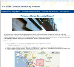
Through the Community Data Collaborative, we are all working together to create an online community data platform tailored to Sarasota County. We are partnering with the Urban Institute to create this online platform. It uses GIS mapping and is neighborhood-centric, with data available at the neighborhood block scale as much as possible. Information includes not only demographics, traditional community indicators, and performance data about available programs and services, but also a diversity of assets and neighbor-generated pictures, stories and videos. It can be updated “real-time” or as frequently as data are gathered. It is designed to enable any of us as residents to bring our own neighborhood into focus, so that we are equipped with meaningful information to inspire resident-led community change. It is possible to “zoom out” and consider a neighborhood relative to surrounding neighborhoods, the whole city, the whole county, and beyond. In-person and online opportunities for ongoing reflection and analysis will exist as well. If anyone is interested in a traditional community report card, it will still be possible for these to be generated too.
To explore the working draft of the online community data platform, please go to: http://nccsweb.urban.org/communityplatform/sarasota
For the original working doc sent to the Urban Institute to establish the architecture of the site, click here.
For a summary of preliminary ideas gathered online in October 2011 to inform the creation of an online community data platform, click here.
For a summary of the preliminary set of data layers that were identified to be included in the Sarasota County online community data platform March - September 2012, click here.
For the most updated summary of data layers for the Sarasota County online community data platform, click here.
To see the contract between the Urban Institute and SCOPE (on behalf of the Community Data Collaborative), click here.
Please note that the Neighborhoods shape file currently being used for the Online Community Data Platform is a slightly modified version of the one used by Sarasota County. Boundaries are slightly adjusted so that no two neighborhoods are claiming the same area. This is necessary for the organizing of community indicators data by neighborhood. For a list of the particular modifications made to the original shape file, click here.
To see a comparison between the population in the Community Data Collaborative Neighborhoods to the population in the 2010 Census Block Groups for Sarasota County, click here.
For a description of how to convert data so that it is organized by neighborhood by conducting a spatial join in ArcGIS, click here.
For a spreadsheet of almost 200 community indicators gathered and tracked in Sarasota County over the past decade, click here.
For an outline of the Composite Map domains and layers developed through SCOPE in 2011/12 as a precursor to the online community data platform of the Community Data Collaborative, click here.
For a comprehensive "Data Dictionary" of Composite Map domains and layers compiled in 2011 for the initial "Community Data 2.0: A Community-Wide Reboot" workshop, click here.